
Quick Answer: A good Wild Atlantic Way itinerary for the southern half takes seven days. Spend two nights in Killarney for the Ring of Kerry, one in Dingle, one in Lahinch or Doolin for Loop Head and the Cliffs of Moher, and two in Galway for the city and Connemara. Fly into Shannon Airport, drive south first, then follow the coast north. With five days you can still see the highlights; with ten you can slow down and add the islands. For the best weather windows and crowd levels, see our month by month guide to the best time to visit Ireland.
The Wild Atlantic Way runs for about 2,500 km down the whole west coast of Ireland, which is far too much for one holiday. Most of our guests choose the southern half instead: Kerry, Clare and Galway. Some drive it themselves, and others hire a private driver in Ireland so they can watch the views instead of the road. Either way, this guide gives you a day-by-day plan, the stops worth your time and the best towns to stay in.
What Is the Wild Atlantic Way?
The Wild Atlantic Way is a signposted coastal touring route that Ireland’s tourism body, Fáilte Ireland, launched in 2014. It runs from the Inishowen Peninsula in Co. Donegal to Kinsale in Co. Cork, along cliffs, beaches, peninsulas and fishing villages. You follow brown signs with a white wavy “WAW” line, and the most dramatic places are marked as Signature Discovery Points.
It is a route, not a single road. Some stretches are main roads, while others are narrow lanes with grass in the middle. That is a big part of its charm, and also why it pays to plan your days carefully.
How Many Days for the Wild Atlantic Way?
To drive the full Wild Atlantic Way at a comfortable pace, you need two to three weeks. For the southern half, from Kerry to Galway, allow:
- 5 days: the highlights only. Skip either Dingle or Connemara, and expect long days in the car.
- 7 days: the right length for most visitors. You see Kerry, Clare and Galway without rushing, and the plan below is built on this.
- 10 days: time for the Skellig Islands, the Aran Islands, the Burren walks and a few quiet mornings.
A useful rule: plan no more than three or four hours of driving a day. Distances look short on the map, but the coast roads are slow, and you will want to stop every few kilometres.
Wild Atlantic Way Itinerary: 7 Days From Kerry to Galway
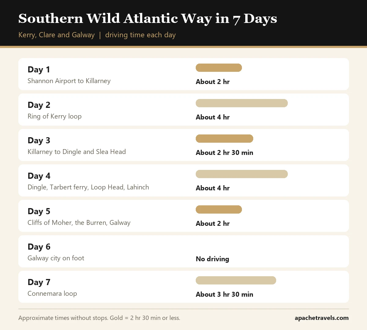
This Wild Atlantic Way route starts and ends at Shannon Airport, which sits in the middle of the southern half. You drive south to Kerry on day one, then work your way back north along the coast.
Day 1: Shannon Airport to Killarney
The drive from Shannon to Killarney takes about two hours. After an overnight flight, keep the day simple. Stretch your legs in Killarney National Park, visit Muckross House and its gardens, or take a jaunting car (a horse and trap) along the lakes. If you fly into Kerry Airport instead, Killarney is only about 15 minutes away.
Day 2: The Ring of Kerry
The Ring of Kerry is a loop of about 179 km around the Iveragh Peninsula, and it deserves a full day. Highlights include Ladies View above the Killarney lakes, the village of Sneem, Derrynane Beach and the views from Coomakista Pass. If you can, add the Skellig Ring, a short detour past Portmagee and Valentia Island.
Tour coaches drive the Ring anticlockwise, from Killarney towards Killorglin. Going the same way means you will not meet them head-on on the narrow stretches. To land on Skellig Michael, a UNESCO World Heritage Site, book a boat from Portmagee weeks ahead. Trips usually run from May to September and depend on the weather.
Day 3: Killarney to Dingle and Slea Head
Drive about an hour to Dingle town, then follow the Slea Head Drive, a loop of roughly 47 km around the tip of the Dingle Peninsula. You pass beehive huts, the Blasket Islands, Coumeenoole Beach and some of the finest sea views on the island of Ireland. Dingle itself is a lively harbour town with good seafood, traditional music and colourful pubs.
If the weather is clear, leave Dingle the next morning by the Conor Pass, one of the highest mountain passes in Ireland. It is narrow, so large vehicles are not allowed over it.
Day 4: Dingle to Loop Head and Lahinch
This is the longest day. Drive north to Tarbert and take the car ferry across the Shannon Estuary to Killimer, in Co. Clare. The crossing takes about 20 minutes and saves you a long drive inland through Limerick. From there, head out to Loop Head, a quiet peninsula with a lighthouse, sea cliffs and very few crowds. Stop in Kilkee on the way back, then spend the night in Lahinch or Doolin.
Lahinch is a surf town with a long beach, and it is also home to one of the best links golf courses in Ireland, if anyone in your group plays.
Day 5: The Cliffs of Moher, the Burren and Galway
Reach the Cliffs of Moher early, before the tour buses. The cliffs run for about 14 km and rise to 214 metres at their highest point. Then drive through the Burren, a strange limestone landscape of bare grey rock and rare wildflowers. Stop at Poulnabrone, a stone tomb more than 5,000 years old, and take the coast road through Fanore and Ballyvaughan.
You will reach Galway city by late afternoon. If you only want a day trip to the cliffs, our guide on getting from Shannon Airport to the Cliffs of Moher compares every option.
Day 6: Galway City
Leave the car parked today. Galway is small and easy to explore on foot. Walk the Latin Quarter and Shop Street, see the Spanish Arch and the River Corrib, and stay for live music in the evening. With an extra day, take a ferry from Rossaveal or Doolin to the Aran Islands and cycle out to Dún Aonghasa, a stone fort on a cliff edge.
Day 7: Connemara and Home
Connemara, west of Galway, is wild country of bogs, lakes and mountains. Drive to Clifden and follow the Sky Road loop, then visit Kylemore Abbey and look out over Killary Harbour, often called Ireland’s fjord. Return to Galway for the night, or head straight to the airport. Galway to Shannon takes about 1 hour 15 minutes, and Galway to Dublin Airport about 2 hours 30 minutes.
Wild Atlantic Way Highlights You Should Not Miss
If you only have time for a few stops on the southern half, make it these:
| Highlight | County | Why go |
|---|---|---|
| Ring of Kerry | Kerry | Mountains, lakes and Atlantic beaches on one loop |
| Skellig Michael | Kerry | An early Christian monastery on a rock out at sea |
| Slea Head Drive | Kerry | The Blasket Islands and the best views on the Dingle Peninsula |
| Loop Head | Clare | Sea cliffs and a lighthouse, without the crowds |
| Cliffs of Moher | Clare | Ireland’s most famous cliffs, up to 214 m high |
| The Burren | Clare | Bare limestone hills, ancient tombs and rare flowers |
| Galway city | Galway | Music, food and a lively old town |
| Connemara | Galway | Kylemore Abbey, the Sky Road and Killary Harbour |
Where to Stay on the Southern Wild Atlantic Way
Changing hotel every night wastes time. Pick a few good bases instead and do day loops from each one:
- Killarney or Kenmare (2 nights): Killarney has the most choice and is close to Kerry Airport. Kenmare is smaller and sits right on the Ring of Kerry.
- Dingle (1 night): book early in summer, as the town is small and fills up quickly.
- Lahinch, Doolin or Ennistymon (1 night): all close to the Cliffs of Moher. Doolin has the music, and Lahinch has the beach.
- Galway city (2 nights): stay central so you can walk everywhere. Clifden is a good alternative if you want more time in Connemara.
For an early flight home on the last day, a night near the airport makes the morning much easier. Our guide to hotels near Shannon Airport covers the best areas.
Driving the Wild Atlantic Way: What to Know
Driving the Wild Atlantic Way is a highlight in itself, but it is not like motorway driving. Keep these points in mind:
- Roads are narrow. Many coast roads have room for one car and a half. Slow down, use the passing places, and pull in for tractors and buses.
- Times are longer than the map says. Allow about an hour for every 50 km on the coast.
- Fill up when you can. Petrol stations are few on the far ends of the peninsulas.
- Do not drive tired. After an overnight flight, keep day one short.
If you have never driven on the left, read our guide to Driving in Ireland as a Tourist before you go. It covers speed limits, roundabouts and the rules that catch visitors out.
When to Go
May, June and September are the sweet spot for the southern Wild Atlantic Way. The days are long, the weather is often good and the roads are quieter than in July and August. In winter, many attractions close or open shorter hours, and boat trips to the Skelligs and the Blaskets stop running. For a month-by-month view of weather and crowds, see our guide to the best time to visit Ireland.
Doing the Route Without Driving
Public transport along the coast is limited, and buses do not reach most of the viewpoints. If you would rather not drive, a chauffeur is the easiest option. We pick guests up at Shannon Airport or Kerry Airport and drive the whole route at their pace, with stops wherever they like. Our Mercedes cars and V-Class vans have room for luggage, and your driver knows the back roads, the best viewpoints and when the coaches arrive.
You can book online or contact our team to plan your days.
Frequently Asked Questions
Where does the Wild Atlantic Way start and end?
It runs between Kinsale in Co. Cork and the Inishowen Peninsula in Co. Donegal. You can drive it in either direction. This guide covers the southern half, from Kerry to Galway.
How many days do you need for the Wild Atlantic Way?
Two to three weeks for the whole route. For the southern half, from Kerry to Galway, seven days is ideal, and five is the minimum.
Which airport is best for the southern Wild Atlantic Way?
Shannon Airport, in Co. Clare. It is about two hours from Killarney, under an hour from the Cliffs of Moher and about 1 hour 15 minutes from Galway. Kerry Airport is handy if you want to start in Kerry.
Should I drive the Wild Atlantic Way north to south or south to north?
Either works. On the plan above, driving south first and then north along the coast means the sea is on your left in Clare and Galway, so it is closer to the passenger side and easier to pull in at viewpoints.
Is the Wild Atlantic Way well signposted?
Yes. Brown signs with the wavy “WAW” symbol mark the route, and the Discovery Points have their own boards. A map or phone is still useful, as some junctions are easy to miss.
Can I do the Wild Atlantic Way without a car?
Partly. Buses link the main towns, such as Killarney, Ennis and Galway, but not most of the coast roads. A private driver or a guided tour is the practical choice if you do not want to drive.
About This Guide
This guide was written by the Apache Travels team in Shannon, Co. Clare. We drive visitors along the Wild Atlantic Way every season. Route details were checked in October 2026 against Discover Ireland’s official Wild Atlantic Way guide, the Cliffs of Moher Experience and Shannon Ferries. Drive times are approximate and assume normal traffic without stops. Opening hours, ferry times and boat trips change with the seasons, so check before you travel.